Ernst-Reuter-Platz
Urban planning and architecture of Ernst-Reuter-Platz
A text on the history of Ernst-Reuter-Platz
by Harald Bodenschatz (with kind permission of the author)
The Ernst-Reuter-Platz is not just any square in Berlin, but a very
a very special square, a central address of the City West, a unique
document of West Berlin’s post-war urban development. Even before the fall of the
the fall of the Wall, this square was somewhat forgotten. Today, however, it is
again: it leaves no one cold, it is loved, or it is not loved.
not loved.
There are two great, contrasting narratives about this square: one of them, a
Hymn to the Square, could be read in the Tagesspiegel on November 19, 2011:
“The square says: Here is progress, here is democracy. Here is the
new beginning. Here is free thinking. […] The Ernst-Reuter-Platz with its reflecting facades
mirrored facades seems […] cool and distant. The bold spirit of
Modernism can be felt here like nowhere else in Berlin. Still.” This
hymn was written by journalist Hartmut Wewetzer. More critical, however
Henry Nielebock, former assistant to Professor Dietmar Grötzebach at the
Grötzebach at the Technical University of Berlin, in his 1996 fundamental work
“Berlin and its squares”: “Submission to the criteria of fast traffic, downzoning
traffic, downzoning and distance regulation, as well as the traditional building line
of the traditional building line, meant in their sum the temporary end of the
of the town square, which had grown and proven itself over the centuries.
town square.” (S. 128)
My initial thesis is: Ernst-Reuter-Platz is, of course, both, an
an impressive urban manifesto of its time, a child of the 1950s,
of the cold war, of the car-oriented and loosened city, a place for science and
science and business. However, it is also a somewhat rigid manifesto, which
that can no longer meet the changing social challenges of a sustainable city without
city without further development.
Forgotten history of the square
Until after the Second World War, there was no real square at this location,
but the so-called knee. which marked the bend of the axial connection between
the two palaces in Berlin and Charlottenburg. A map from
from 1777 shows a star square on the left, today’s large star, on the right
the Charlottenburg Palace, and in the center as the intersection of two axes the
today’s Ernst-Reuter-Platz. The road from Charlottenburg Palace in turn
led across this intersection to a pheasantry and was later called Kurfürstenallee.
The crossing was thus a document of baroque urban planning. Since about 1830
this intersection was called Knie.

System of baroque axes, 1777 (Source: Sonja Miltenberger: Charlottenburg in historischen Karten und Plänen. Berlin 1998, p. 27)
As late as 1857, shortly before Berlin’s tumultuous growth, this system of
baroque axes was largely unchanged. The Kurfürstenallee now opened up
no longer the Pheasantry, but the Zoological Garden. Only with the
the rapid development of the city of Berlin towards the end of the 19th century.
the intersection became more complex: on a map from 1910, the two new streets can be
the two new streets that turned the knee into a traffic junction.
Hardenbergstrasse, which led directly to the center of the New West around the Kaiser Wilhelm
West around the Kaiser Wilhelm Memorial Church, and Marchstrasse,
which led to the workers’ and industrial district of Moabit. Also clearly visible on the
map also the subway station and the many lines of the streetcars.

Die Kreuzung Am Knie, um 1910 (Quelle: Straubes Übersichtsplan Berlin 1910)
The intersection Am Knie, around 1910 (Source: Straubes Übersichtsplan Berlin 1910)
This complex intersection did not change significantly until the Second World War.
significantly until the Second World War. An aerial photograph from 1930 clearly shows the continuum of the
imperial city; the knee was not a barrier, but mediated from east to west and from
to west and from south to north. The Kurfürstenallee was still a –
albeit secondary – part of the street system. In the
National Socialist period, the knee was not fundamentally changed,
however, a kind of traffic circle was introduced around a central island since 1937.
During the war, the buildings on the knee were largely destroyed.

Am Knie, 1930 (Source: Richard Schneider (ed.): Berlin aus der Luft. Destructions of a City 1903-1993. Berlin 1994, p. 70)
After 1945, the dominant model was that of a loosened-up, car-oriented city that wanted to
radically break with the city of the 19th century. An early document
early document is a photo of a model that the planning collective around Hans Scharoun
Hans Scharoun in 1946 wanted to demonstrate the principles of the new city. The later Ernst-
Reuter-Platz was an expressway intersection; the only reminder of the old Berlin was the Charlottenburg
of the old Berlin was the Charlottenburg City Hall.
In 1947, Walter Moest presented the so-called Zehlendorf Plan. On
the knee was a circular square, the Kurfürstenallee had been removed and
detached and lost all meaning. The Hardenbergstrasse and the
Marchstraße were part of an expressway ring. The square was to become, as with
Hans Scharoun to become a center of automobile traffic. Both plans
were not realized, but their car-oriented attitude shaped the further
further urban development.

Vision of the new city, on the lower right the area of the later Ernst-Reuter-Platz, contribution to the exhibition “Berlin plans” in the Berlin Palace, 1946 (Source: Bodenschatz: Platz frei für das neue Berlin. Berlin 1987, p. 138)

Zehlendorf Plan, 1947: Center of the New West (Source: Walter Moest: Der Zehlendorfer Plan. Berlin 1947, p. 44)
While West Berlin was busy planning in the years that followed, construction was already underway in
East Berlin was already under construction. As early as 1952, the final design by
Hermann Henselmann for Strausberger Platz, the first representative new city square
new city square in Berlin after the war. The plan was for a circular
around a green island with a fountain, flanked by a closed development.
flanked by a closed development. This was a shock and put those responsible in West
West Berlin under strong pressure.
The Senate initially responded in our area with a
renaming offensive. In 1953, the knee was renamed in honor of the first Governing
mayor of West Berlin was renamed Ernst-Reuter-Platz, and the
Charlottenburger Chaussee became Straße des 17. Juni. As early as 1950
Kurfürstenallee had already become Hertzallee. 1953 finally saw the beginning of
search for a detailed urban development concept began. Still
1953, a model was presented to the Senate Building Department, showing a giant
traffic square, which was somewhat clumsily flanked by a few not very high new buildings.
clumsily flanked by a few not very high new buildings. Apparently, one was not satisfied with this. In 1955
Bernhard Hermkes was commissioned by the Senator for Building and Housing to design the
design of Ernst-Reuter-Platz. Planning was completed at the end of 1955.
completed. At that time, the square still lay largely fallow.

Model of Ernst-Reuter-Platz, end of 1955 (Source: Architekturmuseum der
TU Berlin)
The model of the Ernst-Reuter-Platz presents the original
urban planning concept. We first see a neat traffic circle around
around a huge central island, on which a water basin with a fountain was
was planned. The pentagonal shape of the basin will be abandoned later.
be abandoned. In the question of the center island, the new square differed
little from Strausberger Platz or from earlier designs for the Reichskanzlerplatz or the
Reichskanzlerplatz or Alexanderplatz. The decisive factor, however, was the
grouping of the buildings. Whereas in East Berlin a closed
traditional architectural language, Hermkes focused on a composition of solitary buildings.
was oriented towards a composition of solitary buildings in a modern architectural idiom that
connected to each other by bridges, enriched by a high-rise building.
a high-rise building. However, all of the buildings made reference to the major east-west axis
because they are parallel or at right angles to it. Striking
was the height differentiation: the high-rise dominated the composition, the two
the composition, the two groups of three discs that characterize the square formed more
modest high-rises, all other buildings that were not located directly on the square were
were significantly lower.
The composition was thus hierarchized in a centralized manner. It was also
astonishingly rigid, because it did not actually allow any shifting of the buildings,
no deviation from the planned heights, and in particular it did not permit any
extensions. Any deviation would have disturbed the overall concept. Such a
composition actually presupposed socialist conditions, or at least an extremely strong
extremely strong Senate building administration. Another interesting aspect is that the
composition was of a purely formal nature; the clients and users had not yet been
and users were not yet determined when it was adopted, but had to be sought out first. This was
a certain problem: because only one user could stand out in terms of urban development
stand out: that of the high-rise building. The users of the six identical panes
could only draw attention to themselves by means of an eye-catching display façade.
The model had another message, not immediately comprehensible today:
The new square was not only to symbolize the new Berlin at the knee, but also
but also – like the Hansa Quarter – the prelude to a radical transformation of the rest of the
the rest of the city – in the direction of a modern, car-friendly, loosened-up Berlin of
composed by solitaires, which should no longer remind us of the past.
reminiscence of the past. The hard break between the new square and its old surroundings, visible in the model
and its old surroundings was in this respect only intended to be temporary.

Cover of a series of postcards of the Senate Building Department, in the center the
Osram House, on the left the Telefunken House, on the right the Pepper House, 1962
Cover of a series of postcards of the Senate Building Department, in the center the
Osram-Haus, left the Telefunken-Haus, right the Pepper-Haus, 1962
The development of Ernst-Reuter-Platz began as early as 1955, independently of the
Hermkes planning. That was the year in which construction began on the complex for the
Faculty of Mining and Metallurgy according to plans by Willy Kreuer. A
three-story low-rise building on the eastern side of the building closed off the former
the former Kurfürstenallee and transformed it into a TU-internal path or
TU path or parking lot. The building was completed in 1959. Willy Kreuer delivered
his own model for a modern Ernst-Reuter-Platz in 1955.
square, which also included a high-rise building between Otto-Suhr-Allee and Bismarckstraße.
was envisaged. Unlike Hermkes, he did not subordinate his lead buildings to the east-west axis.
axis. Kreuer’s concept shows that in 1955, the shape of the square was still
was still controversial.
The Osram administration building was the second building on Ernst-Reuter-Platz.
designed by Bernhard Hermkes for the administration of Osram GmbH in 1956-57.
1956-57, a building that was later used by Eternit AG.
was used. It was also the first building to be realized according to the urban planning
Hermkes’ urban planning concept. The Osram House was followed by the House of
Electricity House, also known as the Telefunken House. It was built from 1958 to 1960 according to
plans by Paul Schwebes and Hans Schoszberger. The high-rise building
with its 80 meters dominates the square to this day. The first floor originally
originally comprised sales rooms of Telefunken GmbH and individual stores. The
second floor contained showrooms for Telefunken. 1960 saw the start of
construction of two additional buildings began. The IBM building was constructed from 1960 to 1961
on the basis of a competition according to plans by Rolf Gutbrod for the
Internationale Baumaschinen GmbH. Finally, from 1960 to
1962, the office and commercial building of the radio wholesaler Karl-Heinz
Pepper GmbH was built according to plans by Franz Heinrich Sobotka and Gustav Müller. In the
first floor were stores and showrooms. The house was also
also used by the University of the Arts. The low-rise building served as the
Building Center Berlin.
After a long break, from 1966 to 1968 the building of the Faculty of Architecture was
was built according to plans by Bernhard Hermkes. This building completed the
three-slice model on the north side of the square. In 1970 it received an
building according to the plans of Hans Scharoun, which, however, did not
no longer corresponded to the urban planning concept of 1956. It was not until the early 1970s that the
1970s, the Raiffeisenhaus by Hans Geber and Otto Risse (1974) and the
and the telecommunications building by Bernhard Binder (1972-1974). Above all
the latter marked a hard break with the urban planning concept of 1956.
Instead of a narrow, elegant slice, it was now a massive, bulky colossus,
bulky colossus, which was no longer left free. Also the two large
north of the square, the bank building built from 1966 to 1968 according to plans by Günter
Hönow, and the administration building erected in 1971 according to plans by Werner
Düttmann on Fraunhoferstrasse, collapsed with the outwardly
the outwardly staggered urban planning concept of Bernhard
Hermkes.

Postcard, 1960s
Not only the grouping of the buildings, but also the large open space was the
was the subject of a comprehensive design concept. After initially
Walter Rossow had been discussed as the landscape architect, at the end of the
1950s, the architect Werner Düttmann prevailed. He contrasted the
traffic traffic circle with a strict grid, which with its 10 by 10 meter squares
squares covered the pedestrian areas and parts of the island. On the
island he planned two water basins and 41 fountains. The island was
1959-60, and the pedestrian tunnel that opened the island was inaugurated in 1960.
inaugurated.

1965
The square was the subject of lavish praise and massive propaganda by the Senate
praise and massive propaganda on the part of the Senate building administration. It was praised as
“most modern square in Germany” (Gausmann, Dagmar: Der Ernst-
Reuter Square in Berlin. The history of a public space of the fifties.
years. Münster 1992, p. 158), or as the “most beautiful square” in Berlin (ibid., 181).
Its water features have been compared to the Fontana di Trevi (ibid., p. 182).
Already in the 1960s, however, critical voices increased. The
realized square apparently could not meet expectations.
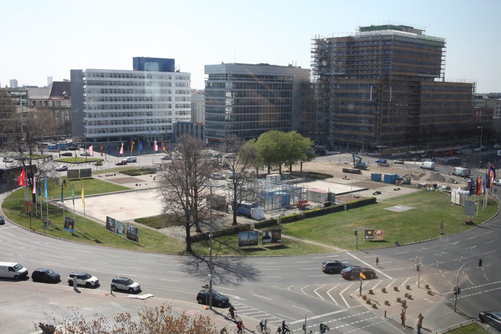
The built Ernst-Reuter-Platz: a monument with tangible shortcomings

Center island of Ernst-Reuter-Platz, November 2011.
(Photo: Harald Bodenschatz)
Another problem is that the motorist, the cyclist and the
pedestrians cannot actually experience Werner Düttmann’s strict grid
experience Werner Düttmann’s strict grid, since it is only accessible from above – a typical example
of helicopter planning. The open space concept also included the in every respect
disturbing plant troughs that now clutter the square and make better bicycle
better bicycle traffic more difficult. The huge inner green space offers in the
water in the warmer months, with a fountain that was temporarily reopened in 1998 after a long
back and forth, was temporarily reactivated in 1998. The round
island is difficult to access and, despite its central location, is completely under
of other offerings, despite its central location, it is completely underused.
The most striking feature, however, was the square’s function as a
traffic junction. Originally, the subway, streetcars,
buses, private cars and bicycles. The most striking change was the abandonment of the
the abandonment of the tramway, which previously occupied a part of the traffic
part of the traffic area and led to a reduction of lanes for private traffic.
traffic. As late as 1960, there were only two lanes there. Since then, the square has
more and more into a gigantic automobile traffic lock, without this lock being
lock was really functional. Everyone who often has to pass this square by car
by car, even if it is by bus, can confirm this. In addition, the priority
of private car traffic led to traffic lights that barely allowed pedestrians to
allowed pedestrians to cross the major streets at once. Pedestrian-friendly, that
was recognized early on, this place really wasn’t.

Plant tubs at Ernst-Reuter-Platz, November 2011
(Photo: Harald Bodenschatz)
To accommodate car traffic, Ernst-Reuter-Platz was very,
very large. Its area is about 4.8 hectares. For comparison:
Strausberger Platz is about 2.5 hectares, the actual center of the
City West, Breitscheidplatz is 3.7 hectares, and the nearby Savignyplatz is
about 2 hectares. The size of Ernst-Reuter-Platz was still noted with pride in the 1950s.
was still noted with pride. It was pointed out, for example, that the square was larger
than St. Mark’s Square in Venice, L’Etoile Square in Paris and even St. Peter’s Square in Rome.
Petersplatz in Rome (Gausmann, Dagmar: Der Ernst-Reuter-Platz in Berlin. The
History of a Public Space of the Fifties. Münster 1992, pp.
172, 179). Ernst-Reuter-Platz does indeed occupy an extraordinarily large amount of
central location, which can hardly be used in its current form.
can be used. This is undoubtedly a problem.
Perspectives for Ernst-Reuter-Platz
Today, Ernst-Reuter-Platz appears as a square with a short-lived history
and without a future. With a short-lived history, because in this place, as in hardly any other
the dream of post-war modernism of erasing all traces of the historic city.
erasing all traces of the historic city. In fact
there is nothing left to remind us of the good 150 years of history that preceded the creation of the square
Place. However, the square also appears to be without a future, since it is not foreseeable so far
how this square can be vitalized due to its rigid and untouchable urban form.
form can be vitalized.
Nevertheless, the square has potential. The task is to find this potential in the first place
without – and this is the great challenge – changing the urban composition.
fundamentally questioning the urban composition. Or in other words
In other words, we need to build this square out of its structure, make it more complex, make it
make it more complex, make it fit for the future. For this purpose, the armor of
protection should not be abandoned, but it should be made more flexible.
This applies first and foremost to the open spaces, the pedestrian areas and the large
island. This is where the square’s greatest potential lies. But it also concerns the
buildings, which should offer even more urban uses on their first floors than before.
uses on their ground floors. This concerns the better networking of the buildings with their
their hinterland. In this context, it would be desirable to have a direct
passage through the low-rise building from the square to Hertzallee. The Ernst-Reuter-
Platz, that would be another task, would have to mediate better from south to north
from City West to Moabit. It must also mediate from east to west
It is the end point of a unique science axis that runs from the Humboldt University to the
Humboldt University to the TU Berlin. Until now, there has been no direct
public transport between these two large city universities. This
brings me to the aspect of representation. The square is today still or again
a location for the sciences and for future-oriented business enterprises.
Three of the four most important buildings on the square are used by the TU Berlin
but actually no one notices that. This square could be the most important
representation space of the TU Berlin, but it is not. Even more, it
should and could be animated much more intensively by the TU Berlin. Last
but not unimportant point: Our country must master the energy transition.
This also means that transportation will change in the medium term.
The mobility of the future will be different from that of today. Is Ernst-Reuter-
Platz capable of change at all in this respect? I think the view of the
with its reduced lanes in 1960 showed that even that is not impossible.
is not impossible.
A lot has already been invested in this place in recent years. The square will
only have a future if the players succeed in developing it beyond isolated individual
further development beyond isolated individual measures. But this is a
Herculean task: The Senate administration is willing, but has few resources. The
district is poor. The TU Berlin also does not have the necessary
resources. The owners on the square are committed, but understandably
understandably, their main concern is their real estate. And the resistance
against sustainable reconstruction will be great. To make the square fit for the future
a concerted political effort is needed to make the square fit for the future.
and supported by the highest political authorities. First and foremost, however
fundamental decision must be made as to whether the square is to be made sustainable
as a space and symbol of science and business with a special profile, and above all
with a special profile, above all as a space of use and representation for the TU
Berlin, as a model of entry into a new mobility. This place deserves more than
cosmetics.